QUESTION IMAGE
Question
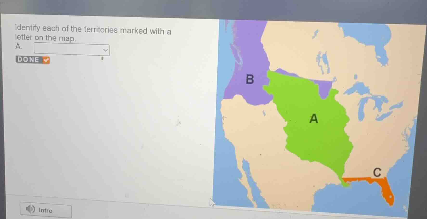
identify each of the territories marked with a letter on the map.
a.
<pre_analysis>
{
"quality": "clear",
"question_count": 1,
"skills_matched": [
"direct_cot",
"blank_filling_formatter",
"explain_then_answer",
"tutor"
],
"needs_drawing": false,
"concepts_used": [],
"new_concepts": [
"Louisiana Purchase",
"Oregon Country",
"Florida Acquisition"
],
"current_concepts": [
"Louisiana Purchase",
"Oregon Country",
"Florida Acquisition",
"Westward Expansion"
]
}
</pre_analysis>
<reasoning>
Analyze territory A
The green region labeled A represents the vast territory in the center of North America, stretching from the Mississippi River to the Rocky Mountains. This region was acquired by the United States from France in 1803 and is known as the Louisiana Purchase.
Analyze territory B
The purple region labeled B represents the Pacific Northwest region, bounded by the Rocky Mountains to the east and the Pacific Ocean to the west. This region was jointly occupied by the United States and Great Britain before being divided at the 49th parallel in 1846. It is known as the Oregon Country (or Oregon Territory).
Analyze territory C
The orange region labeled C represents the peninsula in the southeastern corner of North America. This region was acquired by the United States from Spain through the Adams-Onís Treaty in 1819 and is known as Florida (or the Florida Cession).
Identify the requested label
The prompt specifically asks to identify the territory marked with the letter A. Based on our analysis, territory A is the Louisiana Purchase.
</reasoning>
<answer>
Identify each of the territories marked with a letter on the map.
A. <blank>Louisiana Purchase</blank>
</answer>
<post_analysis>
{
"subject": "Social Science",
"question_type": "Fill-in-the-blank",
"knowledge_point": [
"Social Science",
"U.S. History",
"Westward Expansion"
]
}
</post_analysis>

Snap & solve any problem in the app
Get step-by-step solutions on Sovi AI
Photo-based solutions with guided steps
Explore more problems and detailed explanations
<pre_analysis>
{
"quality": "clear",
"question_count": 1,
"skills_matched": [
"direct_cot",
"blank_filling_formatter",
"explain_then_answer",
"tutor"
],
"needs_drawing": false,
"concepts_used": [],
"new_concepts": [
"Louisiana Purchase",
"Oregon Country",
"Florida Acquisition"
],
"current_concepts": [
"Louisiana Purchase",
"Oregon Country",
"Florida Acquisition",
"Westward Expansion"
]
}
</pre_analysis>
<reasoning>
Analyze territory A
The green region labeled A represents the vast territory in the center of North America, stretching from the Mississippi River to the Rocky Mountains. This region was acquired by the United States from France in 1803 and is known as the Louisiana Purchase.
Analyze territory B
The purple region labeled B represents the Pacific Northwest region, bounded by the Rocky Mountains to the east and the Pacific Ocean to the west. This region was jointly occupied by the United States and Great Britain before being divided at the 49th parallel in 1846. It is known as the Oregon Country (or Oregon Territory).
Analyze territory C
The orange region labeled C represents the peninsula in the southeastern corner of North America. This region was acquired by the United States from Spain through the Adams-Onís Treaty in 1819 and is known as Florida (or the Florida Cession).
Identify the requested label
The prompt specifically asks to identify the territory marked with the letter A. Based on our analysis, territory A is the Louisiana Purchase.
</reasoning>
<answer>
Identify each of the territories marked with a letter on the map.
A. <blank>Louisiana Purchase</blank>
</answer>
<post_analysis>
{
"subject": "Social Science",
"question_type": "Fill-in-the-blank",
"knowledge_point": [
"Social Science",
"U.S. History",
"Westward Expansion"
]
}
</post_analysis>