QUESTION IMAGE
Question
now lets investigate how these plates are moving.
part b - plate movement shown in a hypothetical plate map
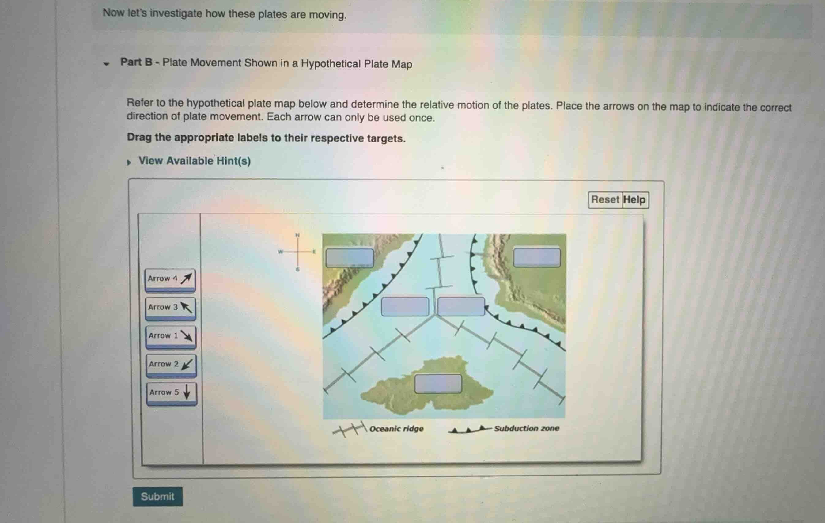
refer to the hypothetical plate map below and determine the relative motion of the plates. place the arrows on the map to indicate the correct direction of plate movement. each arrow can only be used once.
drag the appropriate labels to their respective targets.
Identify plate boundary types
The map shows two main types of plate boundaries:
- Oceanic ridges (marked by double lines with perpendicular ticks): These are divergent boundaries where plates move apart.
- Subduction zones (marked by lines with triangles/teeth): These are convergent boundaries where one plate sinks beneath another. The teeth point toward the overriding plate.
Analyze the central triple junction
The three oceanic ridge segments meet at a central triple junction.
- The vertical ridge segment separates the northwest plate and the northeast plate. Since it is a divergent boundary, the northwest plate must move west/northwest, and the northeast plate must move east/northeast.
- The southwest-trending ridge separates the northwest plate and the southern plate. This means the northwest plate moves away from this ridge (towards the northwest), and the southern plate moves away from it (towards the southeast).
- The southeast-trending ridge separates the northeast plate and the southern plate. This means the northeast plate moves away from this ridge (towards the northeast), and the southern plate moves away from it (towards the southwest).
Determine directions for each target box
Let's analyze the motion of each plate region containing a target box:
- Far-left target (Northwest Plate):
- This plate is bounded by a subduction zone on its left (west) side, with teeth pointing northwest (indicating it is subducting to the northwest under an overriding plate, or converging).
- More directly, it is to the left of the vertical divergent ridge.
- Therefore, this plate must be moving towards the west/northwest.
- Looking at the available arrows:
- Arrow 4 points up-right (northeast).
- Arrow 3 points up-left (northwest).
- Arrow 1 points down-right (southeast).
- Arrow 2 points down-left (southwest).
- Arrow 5 points down (south).
- The arrow pointing northwest is Arrow 3.
- Far-right target (Northeast Plate):
- This plate is to the right of the vertical divergent ridge.
- Therefore, it must be moving towards the east/northeast.
- The arrow pointing northeast is Arrow 4.
- Middle-left target (Northwest Plate near the ridge):
- This target lies on the northwest plate, just left of the vertical ridge.
- Since the entire northwest plate moves northwest, this target must also contain the northwest-pointing arrow, which is Arrow 3.
- Middle-right target (Northeast Plate near the ridge):
- This target lies on the northeast plate, just right of the vertical ridge.
- Since the entire northeast plate moves northeast, this target must also contain the northeast-pointing arrow, which is Arrow 4.
- Bottom target (Southern Plate):
- This plate lies south of both the southwest-trending and southeast-trending ridges.
- Divergence at these ridges means the southern plate must move generally southward.
- The arrow pointing straight down is Arrow 5.
Match arrows to targets
Let's define the five target boxes by their positions on the map:
- **T…

Snap & solve any problem in the app
Get step-by-step solutions on Sovi AI
Photo-based solutions with guided steps
Explore more problems and detailed explanations
Based on the behavior of divergent oceanic ridges (where plates move directly away from the ridge axis) and convergent subduction zones, the correct placement of the arrows into the five target boxes is as follows:
- Top-left box (on the far-left plate): Arrow 3 (\(
warrow\))
- Top-right box (on the far-right plate): Arrow 4 (\(
earrow\))
- Middle-left box (left of the vertical ridge): Arrow 2 (\(\swarrow\))
- Middle-right box (right of the vertical ridge): Arrow 1 (\(\searrow\))
- Bottom box (on the southern island plate): Arrow 5 (\(\downarrow\))